
ABOUT | CONTACT
LONG BEACH
RIVER TRAILS
environmental graphic design
case study proposal
Ongoing. 2015, started
Budget: TBD
This is a self-directed project to examine an Environmental Graphic Design Way-finding solution for the pedestrian and bike path along the Long Beach river trails. This vision is to set a precedent for a unifying system linking neighboring cities along the river trails of Los Angeles County and Orange County.
As a regular user of the river trail pathways, I've observed several navigational issues which this design study aims to address.
Strategic Improvement Goals
- Provide feedback where user can find exits
- Provide users with distances to the next exit
- Identify street crossings
- Cyclists traveling rapidly for exercise purposes do not want to stop for directory signs
- Feedback at critical decision points
BACKGROUND
L.A. RIVER BIKEWAY
This 29.1-mile bikeway follows the east side of the Los Angeles River and extends to the Downtown Marina and the Shoreline Aquatic Park Bike Trail. Along the trail you can find the Los Cerritos Wetlands, a great place to see birds and other wildlife. It will also take you down into the Port of Long Beach and to the Queen Mary.
SAN GABRIEL RIVER BIKE TRAIL
This 28-mile bikeway runs along the San Gabriel River through El Dorado Regional Park and extends to the street surface bike trail near the Alamitos Bay Marina. This is one of the most popular bike paths in the area with hundreds of riders each day.
COYOTE CREEK BIKE TRAIL
This trail splits off from the San Gabriel River for another 2.5 miles in Long Beach, bordering neighboring Los Alamitos, Cerritos, and Hawaiian Gardens. It continues on and links out to the cities of Buena Park, Norwalk, and La Mirada.
Information provided by BikeLongBeach.org
OTHER RIVER TRAILS
Ballona Creek, Playa Del Rey
Compton Creek & Rio Hondo River off Los Angeles River
Santa Ana River in Costa Mesa
San Diego Creek in Irvine
San Juan Creek in Dana Point / San Juan Capistrano
23 RIVER TRAIL ACCESS POINTS IN LONG BEACH
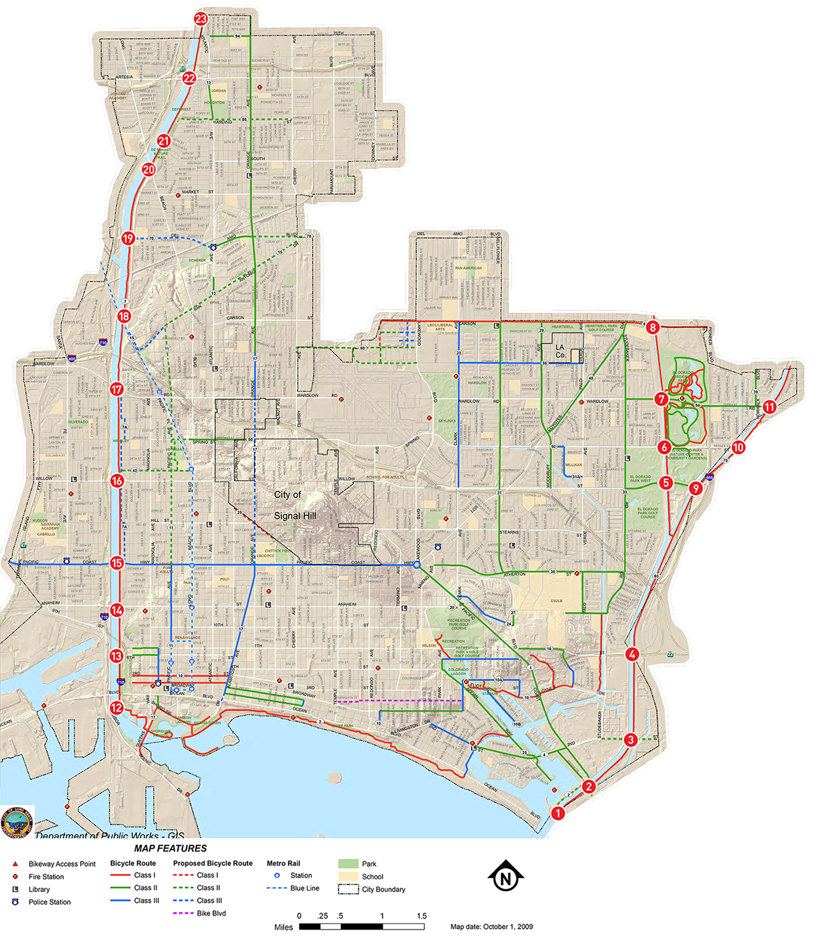
SG-CC BRIDGE
405
3
2
CASE STUDY AREA
WEST SIDE
LOS ANGELES RIVER TRAIL ACCESS POINTS
EAST SIDE
COYOTE CREEK BIKEWAY ACCESS POINTS
KATELLA
GOLDEN SHORE
W 7TH ST
W ANAHEIM
PCH
W WILLOW
W WARDLOW
BIXBY KNOLLS ACCESS
W DEL AMO
LONG BEACH BLVD
E OSGOOD
E ARTESIA
E 72ND ST
W CERRITOS
BALL
WARDLOW
E SPRING
E WILLOW
2ND ST / WESTMINSTER BLVD
PACIFIC COAST HWY
MARINA DRIVE
7TH ST / COLLEGE PARK
E CARSON
EAST SIDE
SAN GABRIEL RIVER TRAIL ACCESS POINTS
1
4
5
6
7
8
9
10
11
12
13
14
15
16
17
18
19
20
21
22
23
CASE STUDY LOCATION IMAGES
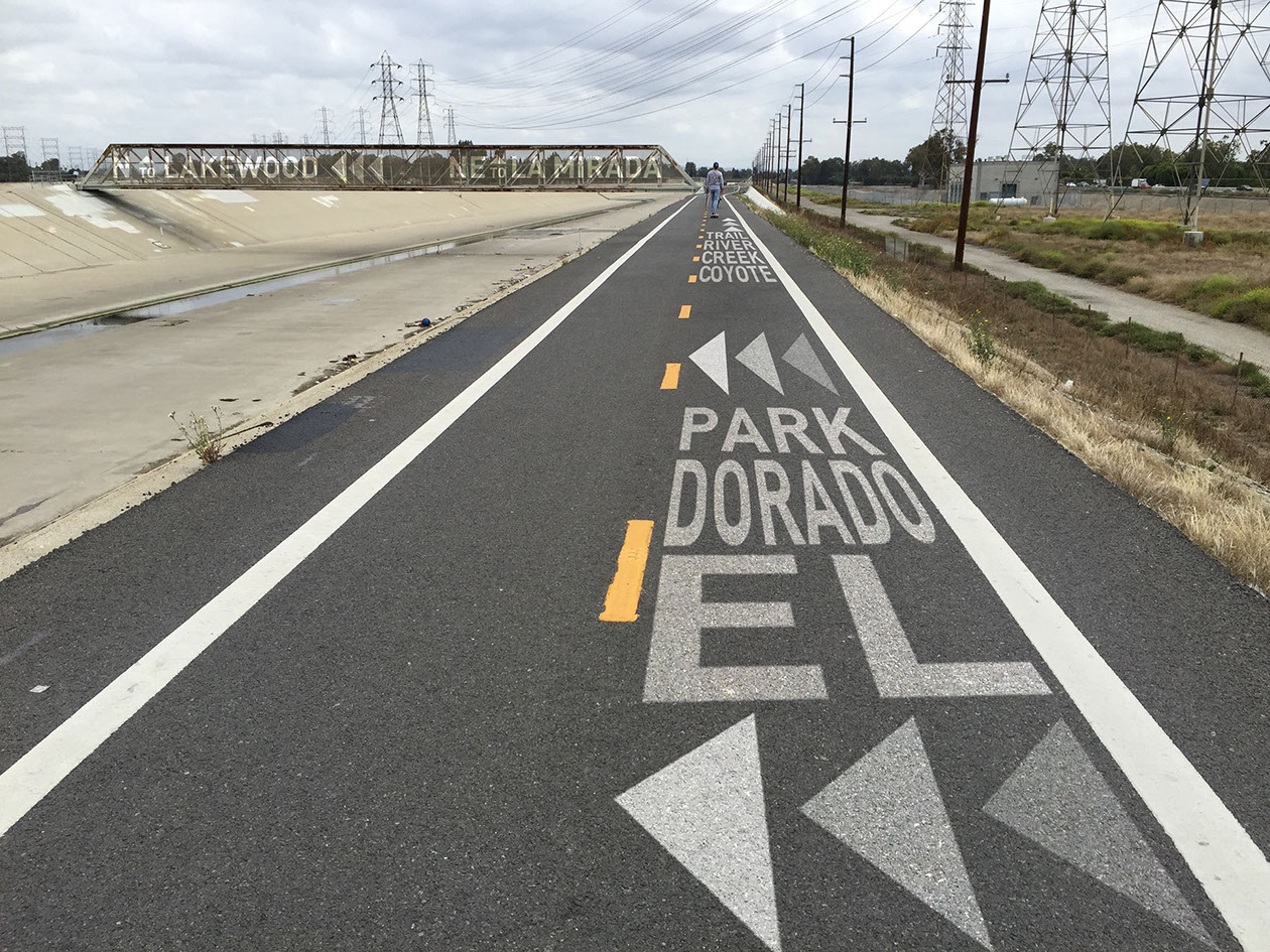
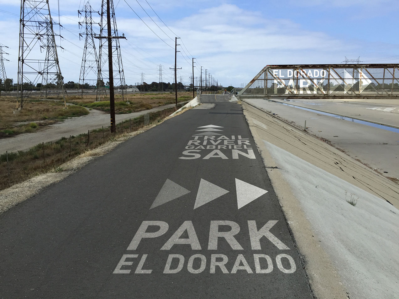
Large, easy to read graphic text applied to both paving and bridge allows users to quickly navigate their location and provides time to consider choices. Large graphic arrows provide intuitive direction guidance.
EL DORADO BRIDGE APPROACH, NORTHBOUND
SG-CC BRIDGE
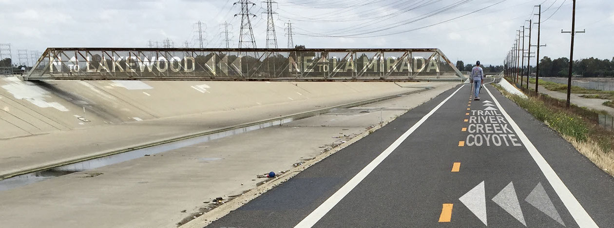
Bridges can provided users with valuable navigational feedback facilitating choices.
EL DORADO BRIDGE APPROACH, SOUTHBOUND
405
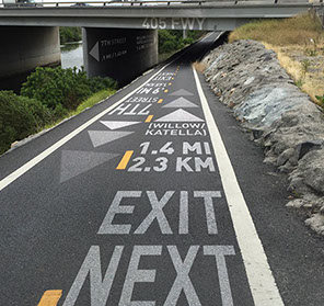
405 UNDERPASS APPROACH, NORTHBOUND
405 UNDERPASS, NORTHBOUND

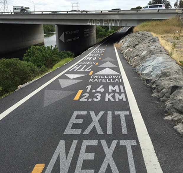
Large, easy to read graphic text applied bridge overpasses allows users location references.
Distance to next exit with next exit street name(s) provides users valuable feedback.
4
BETWEEN 2ND & 7TH STREETS, NORTHBOUND
3
2ND STREET/WESTMINSTER BLVD, NORTHBOUND
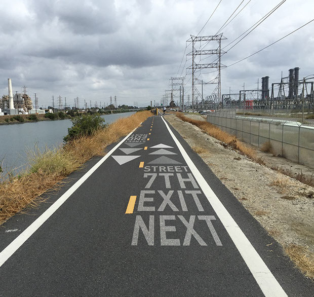
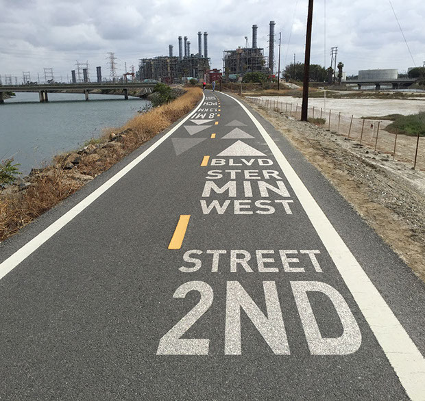
It is easy to forget where one is when between major streets. Periodically text should inform users of upcoming exits.
Text informs users of upcoming exits. Where streets may change along city borders, both street names should be included.
2
PCH, NORTHBOUND DECISION POINT

Graphic text informs users of options at trail decision points.
MESSAGING SCHEDULE
A comprehensive messaging schedule has not been developed at this time. If the project receives support to proceed then we would conduct a more thorough study to refine the messaging.